Digital Forest Inventory for Plantation Forestry
LiDAR-based forest data for accurate inventory, better decisions, and efficient plantation management.
- Tree-level measurements in minutes
- Automated forest analytics and reporting
- Standardized inventory data across plantations
How DFI Works
DFI connects LiDAR-based field measurements with automated forest analytics and a GIS-based dashboard. Watch the 1:15 min. product overview to see how forest inventory becomes digital infrastructure.
Who is DFI for?
DFI enables professional inventory companies and forest managers in Brazil to work with accurate, consistent, and comparable forest inventory data. The platform connects field measurements, automated data processing, and GIS-based analysis in a single digital workflow.
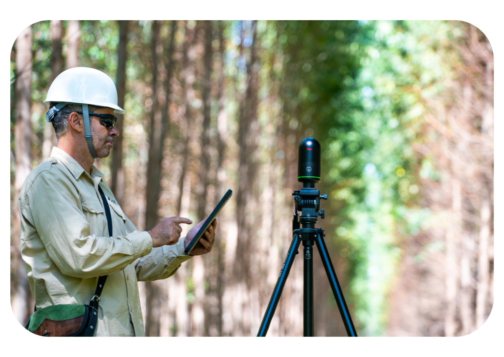
DFI Field Worker
For Inventory Companies
Benefits:
- Fast data capture of up to 10 trees in under 5 minutes.
- High-precision forest inventory results.
- Consistent stand-level insights for reliable planning and reporting.
- Automated processing reduces manual effort and errors.
- Standardized digital workflows across projects.
- Seamless data delivery for landowners and forest managers.
Core Functions:
- Includes a terrestrial laser scanner for high-precision plot measurements.
- Smartphone application for sampling plot creation and management.
- GPS-based navigation and automated sampling plot generator.
- Integrated tree segmentation and measurement (DBH, height, tree volume).
- Automated stand metrics: basal area, canopy cover, deadwood percentage, biodiversity index (box-dimension method).
- GIS dashboard with configurable map layers.
- Shapefile import, export, and creation.
- Offline data capture with synchronized cloud transfer.
DFI Forest Manager
For Forest Owners and Managers
Benefits:
- Structured overview of forest assets and management units.
- High-end, stand-based inventory results with consistent quality standards.
- Comparable inventory data across time and locations.
- Centralized digital access to all inventory information.
- Data suitable for planning, reporting, and documentation.
- Reduced data fragmentation across systems.
Core Functions:
- LiDAR-based digital forest inventory processing.
- Advanced stand-level analytics and aggregation of key forest parameters.
- GIS dashboard with configurable visualization layers.
- Interactive maps (forests, sectors, stands, plots).
- Shapefile import and export.
- User and role management.
- Inventory planning and management tools.
Key Modules of the DFI System
The DFI system connects LiDAR-based field measurement with digital forest analytics, supporting reporting, planning, and long-term plantation management.
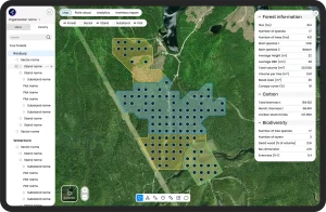
Digital Forest Mapping
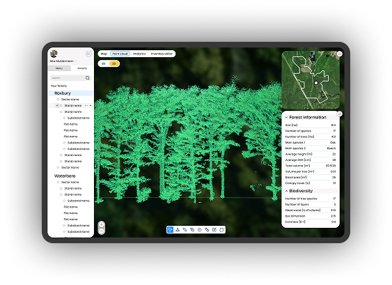
All inventory data is saved within a GIS-based environment, linking plots, stands, and key statistics in one consistent system.
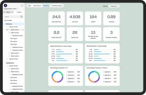
Analytics & Reporting
Standardized datasets and flexible parameter combinations support reporting, documentation, and long-term comparison.
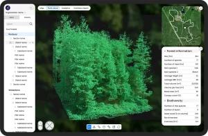
Point Cloud Visualization
Each plot includes a LiDAR-based 3D representation, enabling virtual review of forest structure and stand characteristics.
Our Expertise
15
years in forest inventory
18
years in scientific research
11
in software development


Shaping the Future of Plantation Management in Brazil
With our official launch in Brazil, we are inviting a limited number of strategic partners to join DFI as Founding Partners.
- Preferential launch conditions
- Priority onboarding and implementation
- Direct collaboration with our product and development team
- Strategic visibility as early digital leaders in the Brazilian plantation sector
Watch a short product walkthrough tailored to your role.